The Granting of Maynesboro
On December 31, 1771, Berlin was granted as Maynesborough, also spelled Maynesboro, by colonial Governor John Wentworth. It must have been in the summer of that year when Hubartis Neal, deputy surveyor of the Provincial government, ran the plantation lines in this region. Mr. Neal ran these lines starting at a spruce tree one the southeast corner of the “addition of Shelburne” (Gorham). This line went northeast to a beach tree, which was marked with the letters M. B. P. B. from there the line went northwest to a rock maple tree spotted and marked as aforesaid. The line ran from there southwest to a red birch tree, spotted and marked, then from there ran southwest to the spruce tree where the line began. The names of the grantees were as follows: Sir William Mayne, Robert Mayne, George Gray, John Graham, Walter Kennedy, William Botts, Paul Wentworth, John Nelson, John Ward, Robert Graham, David Scrymgeour, Colin Mackenzie, Thomas Mayne, Edward Mayne, William Scrwens, Robert Needham, Samuel Smith, Thomas Evans, and William Wentworth.
The grantees agreed that they would cut, clear, and make passable carriage roads at their own cost. These roads were suppose to be built within two years of the granting, and were going to be 82 feet six inches wide. The grantees agreed that fifteen families would settle and cultivate the land by the January 1, 1774. The town was to have grown to 60 families by January 1, 1782. All pine trees where to be given to the British Royal Navy for the construction of ships.
The grantees agreed that they would cut, clear, and make passable carriage roads at their own cost. These roads were suppose to be built within two years of the granting, and were going to be 82 feet six inches wide. The grantees agreed that fifteen families would settle and cultivate the land by the January 1, 1774. The town was to have grown to 60 families by January 1, 1782. All pine trees where to be given to the British Royal Navy for the construction of ships.
|
It is not believed that John Wentworth ever set foot in Maynesborough. He explored a part of the White Mountains in the summer of 1772. A more serious expedition was planned for the following year, when the Governor and a company including Benjamin Thompson, who later became Count Rumford, hoped to spend a couple of weeks exploring and surveying the wilderness. For whatever reason, this expedition was canceled. During the summer of 1773, he did, however, go “from Winnipesiokett Pond to White River Falls on Connecticut River, thence up said river to the 45th degree of latitude, and thence by another direction through the pathless wilderness down to the seacoast.”Perhaps, it may be possible that John Wentworth went through Maynesborough without even knowing it.
|
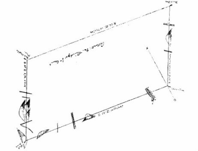
Map of Maynesboro made by Hubartis Neal
|

Governor John Wentworth
|
A copy of the Maynesborough Charter was drawn and engrossed and was then given to the grantees. On August 23, 1775, John Wentworth left Portsmouth on the H. M. S. Scarborough, due to the start American Revolution; with him went the record books containing the Maynesborough Charter, first to Boston and then to England. In 1783, Wentworth came back across the Atlantic to be Lieutenant Governor of Nova Scotia at Halifax. He served this position for the next 16 years. In 1787, in conformity with the seventh article of the peace treaty between the United States and Great Brittan, Wentworth returned the recorded books, which included the charter, into the hands of “President” John Sullivan of the State of New Hampshire, president was an early title used by governors in the young Untied States before Washington became president. The charter books are now in the vaults of the New Hampshire Historical Society. |
References
1. Maynesborough Charter, December 31, 1771.
2. Maynesborough Plantation, which was published in the June, 1929 issue of the Brown Bulletin.
3. The photo of the map made by Hubartis Neal is from the Maynesborough Charter.
4. Portrait of John Wentworth by John Singleton Copley, now housed in the Hood Museum of Art, Dartmouth College, Hanover, N.H.
